HELIOGRAPHIC COORDINATES |
To fix the position of a point on the earth's surface we use two coordinates: latitude and longitude. Latitude is measured from the equator towards the poles and from 0º to 90º. For the length, an origin meridian (Greenwich) is arbitrarily set and, from it, it is measured towards the East and the West, from 0º to 180º. Similarly, in the Sun a heliographic longitude and latitude are defined.
The latitude is determined the same as in our planet: from the solar equator to the poles and from 0º to 90º. To define the length it is necessary to fix a meridian origin, but as there is none especially privileged, we choose, by convention, the meridian corresponding to the ascending node of the solar equator on the ecliptic on January 1, 1854 at 12 o'clock. The length is measured from 0º to 360º towards the west, that is, in the direction of the solar rotation. Thus, knowing the heliographic latitude and longitude we can determine the position of any point on the solar surface.
However, we must not lose sight of the fact that there are no static structures in the Sun and that, therefore, it is normal for the coordinates of a detail to vary over time. If the axes of rotation of the Sun and the Earth were parallel to each other and perpendicular to the ecliptic, the axis of solar rotation would always be in the North-South direction and the solar equator would be a straight line that would pass through the center of the apparent disk. However, the Earth's axis is inclined 23º26 'and points towards the Polar Star, while the axis of solar rotation is inclined 7º15' and is directed towards a point of the constellation of Cepheus located approximately at 23h + 77º.
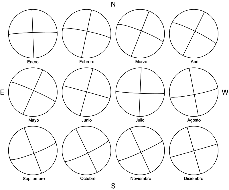
The combination of both inclinations causes, throughout the year, a deviation of the solar axis with respect to the North-South direction and an inclination of the equator with respect to the visual one. Perhaps the best way to appreciate these effects is through an image and, therefore, we reproduce in the following figure the different orientations of the solar disk in the 12 months of the year:
As is logical, this fact greatly influences when calculating the coordinates of a detail, because what we measure in principle is the position of that detail on the apparent disk.
To be able to carry out the correct corrections later, two angles are defined that characterize the position of the coordinate network on the solar disk. The first of these angles is assigned the letter P and is the position angle of the North end of the axis of rotation measured from the North point of the disk, positive towards the East and negative toward the West. P can vary throughout the year from -26º, 32 to + 26º, 32. The following figure is represented with its maximum values:
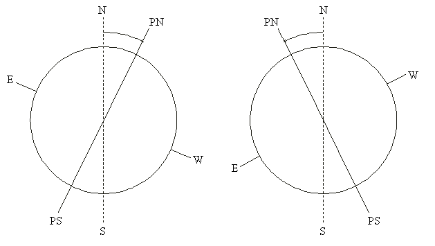
The second angle is designated by the letter B0 and is the heliographic latitude of the center of the disk. B0 can vary from -7º, 25 to + 7º, 25 and gives an idea of the inclination of the equator compared to the visual. Thus, for example, B0 = -5º means that the equator passes 5º north of the center of the disk.
To determine the coordinates of a detail, we will still need a third angle: the length of the central meridian, denoted by L0. It can vary from 0º to 360º and, as the heliographic length is defined, it decreases day by day as the Sun rotates.
Click here to see the values of the angles P, B0 and L0 for the 0h UT of all the days of the year.